blah blah blah
The Great Gulf
Length: 13.0 miles out-and-backDifficulty (click for info): Extreme
Elevation Gain: 2990 feet (+130 feet on return)
Rating (click for info): 9/10
Elevation: 4230' (Spaulding Lake)
Driving Directions:
Trailhead and parking area are on Rt. 16 in Greens Grant, NH (summit is in Thompson and Meserves Purchase). Look for the entrance to the parking area on the west side of the road, 6.3 miles south of the junction with Rt. 2 in Gorham and 1.5 miles north of the entrance to the Mt. Washington Auto Road. Pull into the entrance, marked by a recreation sign for the Great Gulf Wilderness. Drive through an upper lot wtih extra parking, and look for parking in the lower lot, where the drive forms a loop. The trails take off from the far left corner of the loop. Click here for a Google map.
About the Hike:
Drivers on the Mt. Washington Auto Road may not realize that just to their right as they motor toward the summit visitor center, museums, and cafeterias is over 5500 acres of some of the most wild and rugged landscape in New Hampshire. The Great Gulf is one of the state's five federally-designated wilderness areas and concealed in the bottom of the deep and spacious glacial cirque careening down from the summits of Washington and the northern Presidentials are a plethora of scenic delights. The central feature of this valley is the West Branch of the Peabody River, which forms many breathtaking waterfalls on its journey down from the headwall of the gulf. The trek into the Great Gulf becomes progressively more rewarding the further you go, revealing glimpses of monolithic mountain walls, scenic views up boulder-filled streams, and more of these stunning waterfalls and cascades. The hike seems to become progressively more difficult as well the further you go, as you add on more distance and the valley floor becomes more rugged as you weave through boulders above the riverbank, climbing up in altitude. If you make it all the way to the end, you'll come face to face with one of the most incredible mountain scenes in New Hampshire as you view the amphitheater of the gulf's main headwall, strewn with enormous boulders and ledges, from the peaceful and remote shores of Spaulding Lake, where the elevation surpasses the summits of all but the 35 highest mountains in all of New England. Making it all the way out to the lake is a grueling 6.5-mile one-way trek, but the scenery along the way breaks up the trip with many points of interest.
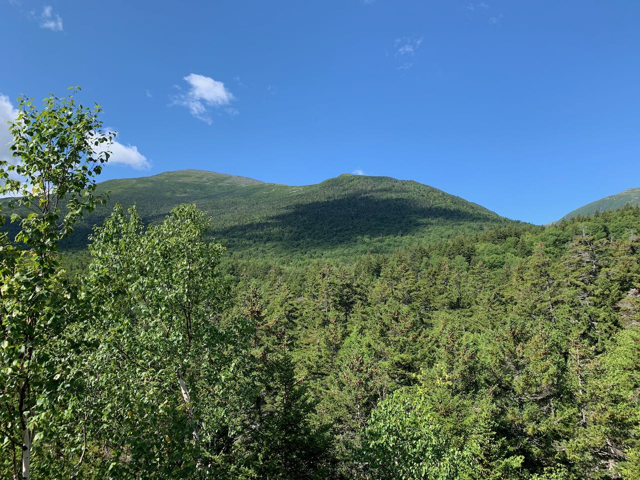
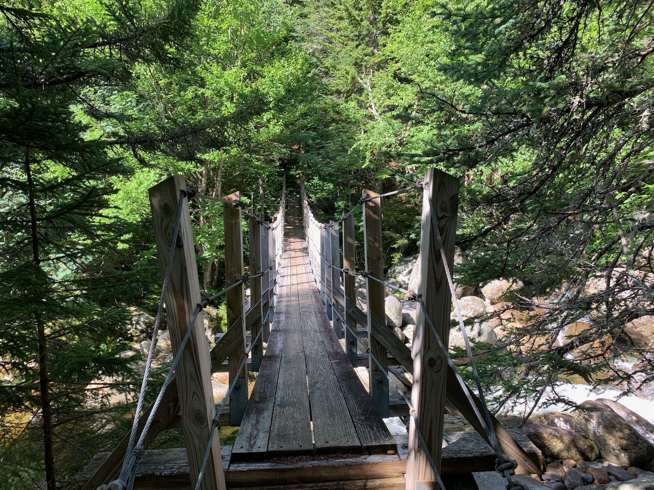
From the information kiosk at the lower end of the parking area, walk down the paved path along the river to the suspension bridge. Cross the bridge and get your first look at the rocky river that will be your on-and-off guide through out the hike. Drop down the stairs off the bridge and climb uphill for a bit to reach a junction with Great Gulf Link at 0.3 miles from the start. Bear left and walk along a smooth surface with just a few roots underfoot from the dark hemlocks surrounding the trail. In this section, the trail doubles as a cross-country ski route. The river remains close by on the left. In another 0.3 miles, bear left as the trail detours around a muddy section of the ski trail. The path narrows and runs rough just atop the riverbank, with rapids and little cascades below, crossing one little stream. It then begins to pull away from the river. Passing by a swampy depression, it runs straight through a hobblebush corridor to rejoin the ski trail after 0.4 miles. The trail ascends gently, crossing a couple streams on wide wooden bridges built for skis (these can be slippery in the summer). In 0.6 miles, the trail passes a ski trail junction and immediately after crosses the boundary line into the Great Gulf Wilderness, marked by a sign. With a rockier surface on the trail, continue 0.2 miles, passing a large boulder, to the next trail junction, where the Osgood Trail takes off to the right. The trail now begins to approach the river again, climbing through mossy rocks along the base of an increasingly steep hill. 0.6 miles past the junction, the trail comes out to an opening right beside the water, where you have the opportunity to explore around the boulders in the river. Just beyond this, the trail climbs a steeper pitch up the bank away from the river. At the top of a rock staircase, it moderates and continues climbing with a couple flat sections to emerge in the gravelly clearing at the top of The Bluff, 0.3 miles from the river. You'll get a glimpse of the high mountaintops as you approach the top. Where several campsites exist across a grassy clearing, scramble up to the top of a boulder on the right side of the trail to see the best view. Over the trail to the left, you can just see the top of the Wildcat Mountain Ski Area. Across the valley from you rises the form of Chandler Ridge, which carries the Mt. Washington Auto Road. Off on the right side, you can see where the interior of the Great Gulf wraps around the corner, although you can't see into the valley floor. Mt. Jefferson overlooks this portion of the gulf, while the triangular summit of Mt. Adams is closer on the right side of the view.
Continue on the trail past The Bluff, and you'll soon reach a junction with Osgood Cutoff. Turn left and drop sharply downhill to cross Parapet Brook, a sizeable watercourse, but one that is usually not too hard to step across on large rocks. On the other side, it climbs up to the crest of a little ridge where trees are sparse and the mountaintops can be glimpsed. Stay straight through a trail junction with Madison Gulf Trail on the right and a path to some campsites on the left. The trail drops down again and crosses over the West Branch with the aid of another suspension bridge. Enjoy the view upstream over numerous cascades and chutes. Just up the bank on the other side, the other branch of Madison Gulf Trail turns off to the left, 0.2 miles past The Bluff. After this quick detour uphill, the trail drops back down to the riverside, where just through the trees, several more scenic cascades roar. Step out onto the boulders in the channel of the river for a nice framed view upstream toward the peak of Mt. Adams. Just a bit further up along the river, the trail passes by a large and unusually shaped and positioned boulder known as Clam Rock, another 0.2 miles past the junction. With a broad, flat overhanging face and jagged upper edge in the pattern of a clam shell, if you stand at the right angle underneath the overhang, the steady rushing sound of the river becomes amplified just as with a seashell held to the ear. Continuing on the trail, pass into an extraordinarily lush and mossy landscape where diminutive spruce trees spring up from the hillside all around. The trail stays quite close to the river, with travel becoming more arduous over and around rocks in a narrower pathway. Continue to watch for pretty cascades in the river, as the trail comes alongside a couple openings on the riverbank, including one deep, stony pool. After 0.8 miles, the trail crosses Chandler Brook in a wide and shallow section that could be difficult to get past if water is high. Continue straight past Chandler Brook Trail, a connecting link to the auto road. The trail climbs steeply for a bit, then continues in proximity to the West Branch, which can be seen through the trees. It soon returns to the riverbank and continues through more of the same alluring forest, filled with moss, low spruces, and the occasional boulder. After 0.6 miles, glimpses appear through the trees of the two rocky shoulders of Mt. Jefferson called the "Jefferson's Knees", and you'll soon arrive at a four-way trail junction with Wamsutta Trail on the left and Six Husbands Trail on the right. Proceed straight on the Great Gulf Trail.
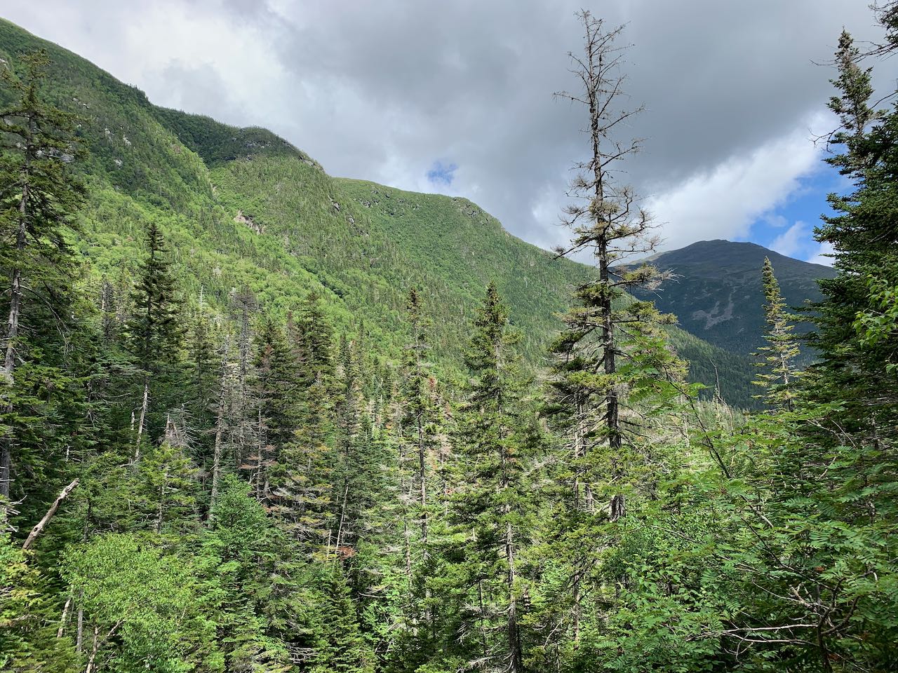
The trail enters a dense forest with intermittent breaks in the trees where the craggy mountainsides all around become visible. It passes a campsite clearing, and after 0.3 miles crosses a small brook. It remains close to the West Branch, dwindling in size now that you're further upstream, for another 0.3 miles. After crossing another smaller brook, it climbs a particularly rocky pitch through boulders, passing a small cascade, and comes out onto the edge of an often-slippery ledge slab. The most difficult section of the trail in the floor of the gulf commences, as you must climb steeply up the ledges alongside the river. Stay close to the trees and use them for support, as the footing is uncertain on the mossy and damp rock. You'll soon come out onto the most open ledges, where the reward for your effort is an incredible, long cascade chain with a view out to the mountains. Enjoy the scenery as the water crashes through boulders above and snakes down over the uneven ledge surface. The top of the ledges is an excellent spot to take a break and enjoy the view. From here you can see both of the Jefferson's Knees and Mt. Adams. The direction from which you view the mountains gives an indication of how far you've hiked into the gulf.
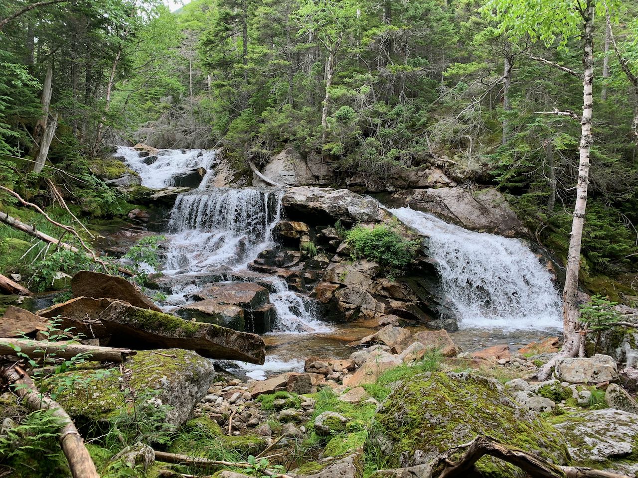
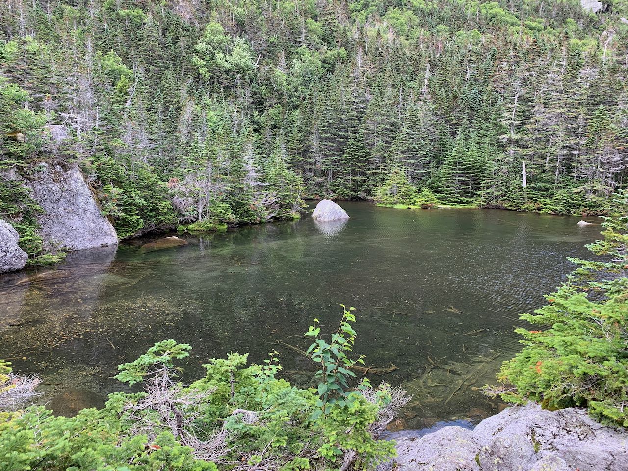
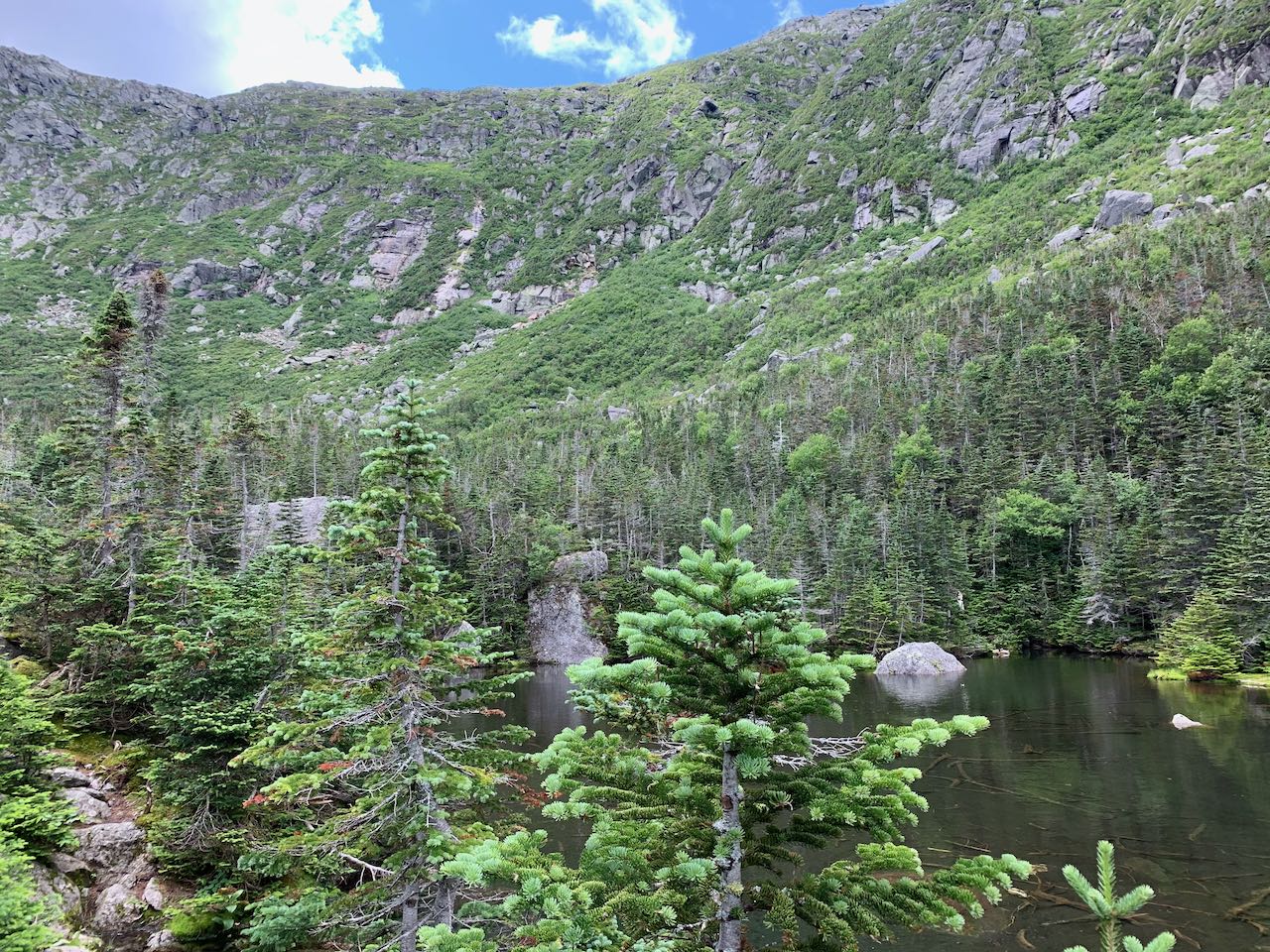
The trail continues up along the edge of the ledges beside the wild river, passing another sizeable cascade before ducking back into the woods after 0.3 miles mostly out in the open. It crosses an unnamed brook flowing down from Chandler Ridge, then passes by what could be the most beautiful waterfall in the gulf, where the river cascades down past a ledge wall and splits into two wide, side-by-side plunges that fan out majestically for your viewing pleasure. After 0.2 miles between crossings, the trail crosses the west branch on small rocks. Though now small enough to be passable on foot, this crossing can be difficult and unsteady. Now weaving through an area with a deep-woods aura, the trail crosses a brook of similar size that flows down from Sphinx Col and quickly reaches a junction with Sphinx Trail after another 0.1 miles. Bear left. Just as the river is dwindling in size as you travel upstream, so the Great Gulf Trail becomes wilder and less used with each trail junction you pass. From this point on, no other trails diverge until the Great Gulf Trail reaches the summit of Mt. Washington. Just past the junction, cross the West Branch back to the other side. Again, use caution here as the small stones to step on can be slippery and unsteady. In 0.1 miles you'll reach Weetamoo Cascade, a majestic waterfall that spreads out over a blocky ledge and flows into an emerald-tinged pool. In another 0.1 miles the trail crosses a smaller brook. Weaving through yet more lush and mossy areas scattered with boulders, the trail approaches a region where blowdowns are frequent all through the forest. It crosses another litle brook after 0.3 miles and soon climbs into a more open blowdown patch where you'll start to see the gulf walls encircling you. In another 0.3 miles, the next brook is crossed, and the trail climbs a final 0.1 miles to an opening at the north end of Spaulding Lake, where the forest opens up and you can take in the breathtakingly rugged landscape surrounding the tiny pond. All the water draining down thhrough the ravines collects into this tranquil pool and forms the headwaters of the river. It is an awe-inspiring sight with the broken cliffs and talus slopes rising well over a thousand feet on three sides. Spaulding Lake is only 200 feet in length, so walk over to the other side and find the best spot to enjoy the view. Your trip ends here, unless you have the ambition to tackle the arduous slog up the headwall to the top of Mt. Washington - one of the most challenging ways to summit New Hampshire's highest, but one that rewards with scenery like no other.
Printable directions page